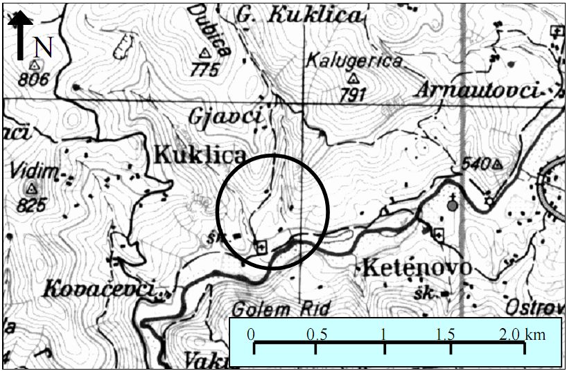
Fig. 1: Location of the earth pyramids in the Kukle area (the circle represent location of the pyramids, and from the right side is part of the road Stracin-Kratovo)
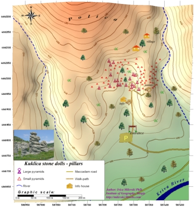
Fig. 2. Map of the Kukle area with the surrounding landscape
Published in the journal: Geographic Review No. 35, Skopje, 2000. Author: Ivica Milevski, PhD, Institute of Geography, FNSM, Skopje
|
EARTH PYRAMIDS (PILLARS) IN KUKLICA-KRATOVO AREA |
|
ABSTRACT
Earth pyramids (or earth pillars) are specific landforms created with processes of severe soil erosion and denudation. Because of high overall erosion intensity, in Republic of Macedonia such phenomena are occurring in several localities: in the Bosava river catchment near village Konopiste (south part of the country), in the Males and Pijanec depressions (upper part of Bregalnica catchment), in Petrosnica valey (Pcinja river tributary) and other localities. But the most interesting occurrence of earth pyramids with typical characteristics is located in the area of Kuklica village (north-west from the Kratovo town). These pyramids (pillars) are interesting in the aspect of their largeness, morphology, genesis and significance.
Key words: earth pyramids (pillars), soil erosion, denudation, accumulation.
Introduction
In geomorphological view, the north valley side of Kriva River between villages Ketenovo and Sopsko Rudari (north-west from Kratovo) is characterized by severe denudation and soil erosion processes. That is result of appropriate geologic and soil structure, south-sided steep slope of the terrain, precipitation regime with high surface runoff and lack of permanent vegetation cover. As a consequence, landscape in this area has numerous forms of denudation, soil erosion (sheet, rill and gully erosion), as well as areas with dominant deposition of the eroded material. Most interesting landforms created with denudation are earth pyramids (pillars). They appear fragmentary in one wide belt of the right (north) valley side of Kratovska River, in the Kuklica village (Lower Kuklica). The pillars are best expressed in the locality Kukle, 6 km downstream from the Ketenovo village (the village is on the road Stracin-Kratovo). Here, more than 150 pillars were registered, covering area of 0.3 km2. Formation of the earth pyramids is result of number of factors - from local natural-geographic, to the anthropogenic influence in the landscape which reinforce denudation and soil erosion.
|
Fig. 1: Location of the earth pyramids in the Kukle area (the circle represent location of the pyramids, and from the right side is part of the road Stracin-Kratovo) |
|
Fig. 2. Map of the Kukle area with the surrounding landscape
|
Factors for earth pyramids formation
As it is mentioned before, for creation of earth pyramids or pillars, some settings are necessary. They are almost ideally present in the research area, which actually permit creation of typical forms. From these factors, several have especial significance:
Geologic (lithology) structure of the terrain;
Topography and morphology of the area;
Climate, especially pluvial and temperature regime;
Hydrographic characteristics and
Vegetation characteristics.
Geology
In geological view, the region of Kuklica where the earth pyramids are located is composed by volcanic rocks of Kratovo-Zletovo palaeovolcanic area. Below topsoil layer 20-50 cm deep (which is mostly eroded) is 1-2 m thick layer of erodible andesitic tuff from the younger eruption phases. Their composition and structure indicate consolidation in lacustrine waters (Hristov & Karajovanovic, 1969). Andesitic tuffs owerlays discordantly on the upper Eocene sediments. They are white to yellow-like colored, highly erodible and subdue to pluvial erosion and with thickness of 20-30 m.
Below andesitic tuffs is a thin (0.5 m) layer of compact volcanic rocks: dacite-andesitic ignimbrites which are the major factor enabling formations of typical earth pyramids in the area. Ignimbrites cover another layer of andesitic tuffs from older effusive phases with the thickness of 20 m. When uncovered on the surface, as a result of weathering, ignimbrites decompose and break-up to the greater or smaller blocks. These blocks in contrast to the tuffs beneath are much more resistant to the pluvial erosion. In that manner, they protect the tuffs, i.e. have a role of “protecting cope”.
Thus, dominant place in the geologic structure of the Kuklica area have andezitic tuffs who like volcanoclastic material are hardly liable of erosion processes, and which thickness enable creation of typical landforms.
Terrain morphology
Terrain morphology of the area has significant importance for earth pyramids formation. In general, terrain is highly dissected. On the north is Dubica mount (776 m), and to the east are Kaludjerica mount (791 m), and Vidim mount (825 m) divided with short but deep, narrow valleys which follow to the Kriva River. Steep valley slopes composed generally by andesitic rocks are under severe weathering and denudation. With erosion of the terrain, smaller and larger rocks, escarpments are formed.
In south direction, mount sides gradually lowering over three river terraces (60-70 m, 30 m and 5 m) up to the riverbed of Kriva River on 390 masl. Area of the earth pyramids has generally south inclination which causes to be exposed to the direct solar radiation, which in turn has effect on the thermal weathering of the rocks, especially of the dacitic-andesites ones.
Earth pyramids itself are builted in the lower right (north) river terrace (30 m) of the Kriva River valley, i.e. on the south side of Dubica mount. They are 300 m apart from the riverbed of Kriva River, located on 415-420 masl. Because south sides of Dubica mount has steep slopes and weak vegetation, overland flow waters occurred during the rainstorms has great erosion potential. With severe surface erosion, they heaved and still have significant role in earth pyramids formation.
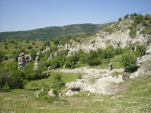 Fig. 3. Earth pillars from the west side of the Zabel mount. In the front is small rounded depression with large pillars called "jolly wedding" |
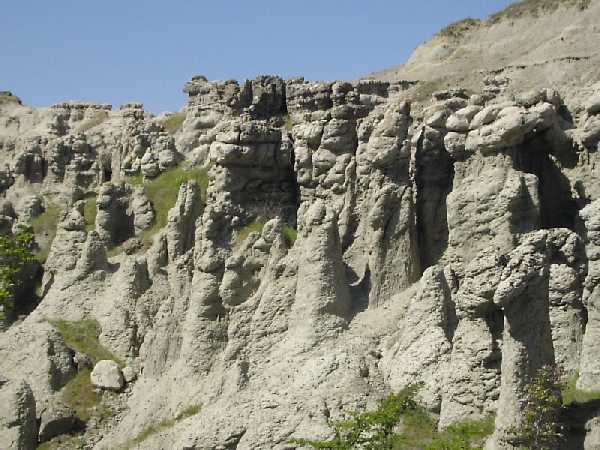
Fig. 4. Earth pyramids from the east side of Zabel mount |

Fig. 5. Pillar with interesting shape representing human being. In the background is non-eroded part of the Kriva River terrace where is yet active process of pillars creation.
|

Fig. 6. Scheme of creation of the large earth pyramids from the initial phase up to day (dashed line represent the layer of ignimbrites)
|
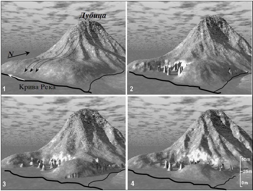 |
Fig. 7. Computer modeling of earth pyramids evolution (landscape is represented without surroundings 1. Area of Kukle before pillars formation 2. Large pillars creation 3. Recent situation 4. Future evolution with constant intensity of erosion
|